Recreational Fisheries
Until the 1970's, it was thought that commercial fisheries took the greater part of the total marine fishery catch in the waters of the United States. However, most species of fish in estuarine and inshore areas, as well as many in open waters, are harvested jointly by recreational and commercial fishermen. Catches by the marine recreational fishery are a significant portion of the total landings of many marine species. Passage of the Magnuson Fishery Conservation and Management Act (MFCMA, 16 USC 1801) in 1976 mandated collection of data for both commercial and recreational marine fisheries. Following several years of testing, a standard method of data collection and statistical estimation was initiated in 1981. Catch, effort, and participation estimates for marine recreational fisheries have been produced since 1981. Catch, effort, and participation statistics are fundamental for assessing the influence of fishing on any stock of fish. The quantities taken, the fishing effort, and the seasonal and geographical distribution of the catch and effort are required for the development of rational management policies and plans. Continuous monitoring of catch, effort, and participation is needed to monitor trends, to evaluate the impacts of management regulations, and to project what impacts various management scenarios will have on a fishery. AUTHORIZATION
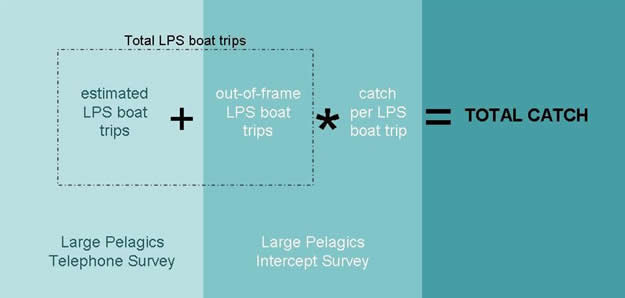
METHODOLOGY  To address this issue, several changes were made as part of the new MRIP APAIS estimation method. First and foremost, a design-based method for estimating catch rate from the APAIS data was developed to calculate new MRIP estimates. Additionally, all non-probability convenience sample data, previously included in the MRFSS APAIS, has been eliminated from MRIP APAIS estimation. Lastly, a statistical adjustment has been applied to account for the fact that only a fraction of all the anglers were being observed at a selected site during a sampled day. This improved method has been used to calculate revised Atlantic and Gulf coast catch and effort estimates back through 2004. Please visit www.countmyfish.noaa.gov for additional resources on the revised MRIP estimates. The Coastal Household Telephone Survey (CHTS) The CHTS collects fishing effort data from shore and private boat anglers. Because the majority of shore and private boat fishing trips are taken by individuals who live in coastal areas, the CHTS is limited to households located in coastal counties. Correction factors derived from the intercept survey are used to account for trips taken by non-coastal resident and out-of-state anglers, as well as anglers who live in households without telephones. Data collection occurs during a two-week period at the end of each two-month sample period (or “wave”). In 2006 the survey was conducted for the entire year (January through December or waves 1-6) on the Pacific coast, the Gulf of Mexico coast, the Atlantic coast of Florida, Hawaii, and Puerto Rico. The survey was conducted for ten months (March through December or waves 2-6) on the Atlantic coast north of Florida, except for Maine and New Hampshire, where it was conducted for six months (May through October or waves 3-5). This regional annual schedule has been maintained since the survey inception in 1979 although not all states, or commonwealths, have been surveyed in all years (see Geographic Coverage section). The CHTS is currently being conducted in the Pacific coast sub-regions (CA, OR, WA) concurrently with Pacific States Marine Fisheries Commission-coordinated state surveys to evaluate alternative angler effort methodologies (Pacific RecFIN hyperlink). The CHTS specifically excludes Texas and Alaska, who conduct their own recreational fishing surveys. The CHTS utilizes a computer-assisted, random digit dialing (RDD) approach to contact full-time residential households. Contacted households are screened to determine if any household members participated in marine recreational fishing during the previous 2 months, and each active angler is asked to recall the number of saltwater fishing trips that were taken during the wave, as well as provide details about each trip. Institutional housing, businesses, wireless phones, and pay phones are excluded from the survey. Within each state, sample is allocated among coastal counties in proportion to household populations. For each coastal county, data from the CHTS are used to estimate the average number of trips per household, which is then expanded by the county household population to estimate total trips. County estimates are summed and then expanded by intercept survey adjustment factors to produce state-level effort estimates. All estimates are computed by fishing mode, then all mode-level estimates are aggregated to obtain the total statewide estimates. For-Hire Telephone Survey (FHS) The FHS was developed to resolve undercoverage of Charter and Party boat angler effort by the CHTS. The CHTS does not capture the majority of for-hire angling effort in most states because most anglers who take trips on Charter and Head (or Party) boats do not live in coastal counties. A series of pilot studies to obtain fishing effort information directly from Charter boat operators was conducted in North Carolina and Maine, then throughout the Gulf of Mexico sampling region (Louisiana - West Florida). After several years of testing, the FHS was implemented as the ‘official’ methodology for obtaining Gulf of Mexico Charter boat effort in January, 2000. This FHS design was then pilot tested against a logbook program and the CHTS in South Carolina in 2000 and included Head boats as well as Charter boats. The FHS was implemented for all Atlantic Coast states from Maine through Georgia in January 2005. It overlaps other charter and headboat monitoring programs, including the Northeast (Maine-Virginia) Vessel Trip Reporting Program (VTR), the Southeast Regional Headboat Survey (SERHS), various state logbook programs, and the ongoing CHTS. The sampling unit for the FHS is not the household but the individual for-hire vessel. The sample frame is constructed from a comprehensive directory of for-hire boats for all states, from Maine through Georgia. The vessel directory consists of a vessel identifier (vessel name or registration number), the name, address and telephone number of an identified vessel representative (captain or owner), as well as a variety of accessory information, such as eligibility, activity, and cooperation status. Sampling is stratified by vessel type (head boat and charter boat), state, and week, within each two-month sampling wave. Currently, vessels are sampled at a rate of 10% within each stratum, with a minimum sample size of 3 vessels. Data collection is conducted on a weekly basis during all weeks within each wave. The weekly dialing is completed during the weekfollowing the specified sample week of fishing. Respondents are asked to report vessel fishing activity for the prior week, and then asked to profile each for-hire fishing trip. Information obtained for each trip includes area fished, number of anglers who fished, hours of actual fishing activity, method of fishing, and target species, if any. Advance notice of selection is mailed to each selected vessel representative and alternative reporting modes are provided for the Atlantic Coast respondents, including an interactive website, a fax number and a phone contact for respondent-initiated interviewing. Effort estimates are produced from the average number of angler-trips per vessel-type per week and the number of vessels per vessel-type in the sampling frame. Adjustment factors for active for-hire fishing boats that are not in the sample frame (new to fleet, no contact information known, etc.) are produced from field intercept survey questions and applied to the raw effort estimate. Access-Point Angler Intercept Survey (APAIS) The access-point angler intercept survey is conducted at public marine fishing access points (boat ramps, piers, beaches, jettys, bridges, marinas, etc.) to collect individual catch data, including species identification, total number of each species, and length and weight measurements of individual fishes, as well as some angler-specific information about the fishing trip and the angler’s fishing behavior. The interviews are conducted in person by trained field staff, and the sites and dates are selected by a proportional random selection process such that those sites that have the most activity within a sample month will be selected for interview collection most often. The sampling schedule is independently determined by fishing mode (shore fishers, charter boat fishers, or private or rental boat fishers) and target sample sizes are based on statistical power and available funds. From these angler-interviews a catch per trip estimate (cpue) can be made for each type of fish encountered, either observed or reported. These cpue estimates are combined with the effort estimates by sampling stratum to produce the catch and harvest estimates. Questions are also asked that provide the information to adjust for non-coastal residents’ effort, fishing activity by anglers living in households without traditional landline telephone service, and charter boat anglers fishing from boats that are not in the FHS sample frame for the wave. The Large Pelagics Survey (LPS) The Large Pelagics Survey (LPS) is specifically designed to collect information on recreational fishing directed at large pelagic species (e.g., tunas, billfishes, swordfish, sharks, wahoo, dolphin, and amberjack). Offshore trips targeting large pelagics typically make up a relatively small proportion of all recreational fishing trips. Using this specialized survey design allows for higher levels of sampling large pelagic trips, which ultimately improves estimates of catch and effort for large pelagics. The LPS has been conducted since 1992 from Maine through Virginia. The LPS includes two independent, complementary surveys which provide the effort and average catch per trip estimates needed to estimate total catch by species. The Large Pelagics Intercept Survey (LPIS) is a dockside survey of private and charterboat captains who have just completed fishing trips directed at large pelagic species. This survey is conducted at public fishing access sites that are likely to be used by offshore anglers, and is primarily designed to collect detailed catch data. The Large Pelagics Telephone Survey (LPTS) collects fishing effort information directly from captains holding Highly Migratory Species (HMS) permits (required by NOAA Fisheries to land these species). The LPTS is stratified by permit category: HMS Angling and Atlantic Tunas General permits and HMS Charter/Headboat permits. Data from the phone survey are used to estimate the total number of boat trips on which anglers fished with rod and reel or handline for large pelagic species. The LPS differs from the standard marine recreational fishing surveys mainly in estimating effort and catch by BOAT, rather than by angler. Information on the number of anglers per boat-trip is collected by the LPIS, but the primary unit for all estimates is the boat-trip, or boat-day of fishing. Additional information collected during LPIS and LPTS interviews include target species, tournament participation, fishing method used, fishing location, water depth, and water temperature.
Highly Migratory Species (HMS) Catch Card Census Program Last Updated: January 24, 2012 |
|||||||||||||||||||||