The
C oastal &
O ceanic
P lankton
E cology,
P roduction &
O bservation
D atabase
|
What are Spatial Fields?
The COPEPOD database contains millions of observations sampled on thousands of oceanographic cruises.
These cruises are assembled into hundreds data sets, usually representing logical clusters of plankton sampling done in association with a project, program, or institution.
In addition to these individual data sets, COPEPOD also assembles those observations into compilations, perhaps representing a geographic region (e.g., the North Atlantic) or all available data from a taxonomic group (e.g., "copepods" or "diatoms").
The key thing to note is that these data and compilations are "raw" and generally do not have a common method or quantitatively comparable unit.
This means a user must carefully apply and/or combine these data (if possible at all).
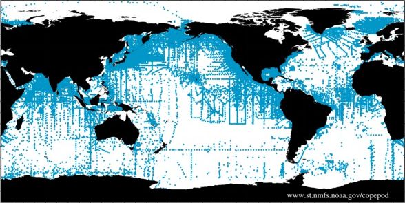
Raw Data Compilation
many different methods and units
|
Standardized Spatial Field
without missing-data or gap filling
|

Analyzed Spatial Field
modelled or interpolated gap filling
|
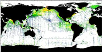
Spatial fields (also called "gridded fields") represent standardized or common-method values (with common units) stored in a fixed-spacing grid (e.g., "1-by-1 degree" or "1/4-by-1/4 degree" longitude-by-latitude).
One example of spatial fields is data measured by satellites (e.g., sea surface temperature or ocean-color-derived chlorophyll).
Spatial fields can also be created by combining calibrated-methods/common-units values of temperature, salinity, nutrients, or plankton biomass.
These fields can be simple (e.g., gridded without smoothing or interpolating to fill in gaps) or advanced (e.g., blended in situ and satellite data with additional model-based interpolation and outlier detection).
The most common type of spatial field contains average values (e.g., "annual temperatures", "July nitrate concentration"), but there are also fields of standard deviations, standard errors, anomalies (difference from the long-term average or climatology), and even trend (slope or rate of change over time).
( Compilations are located in the Databases section. )
Standardized Spatial Mean Fields: in-situ fields without interpolation or modelling
Analyzed Spatial Mean Fields: Interpolated and/or modelled biomass fields
- Stromberg et al. 2009 modelled biomass fields (offline - contact Todd for status/availability)
See also NAUPLIUS and its Explorer fields.
|
|
|