| |
 |
 |
 |
|
|
|
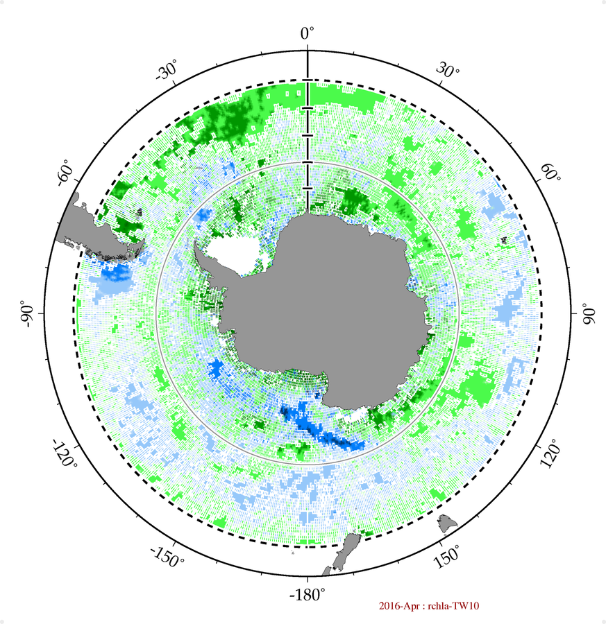
Latitude-adjusted CHL data field
surface area = 59.6 million km2 |
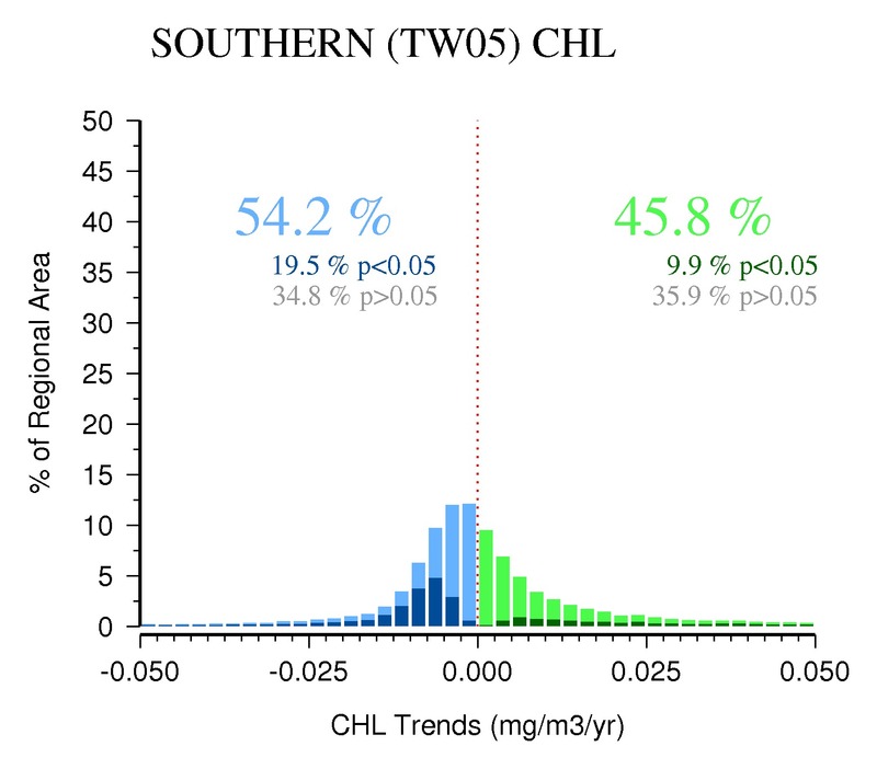
05-Year
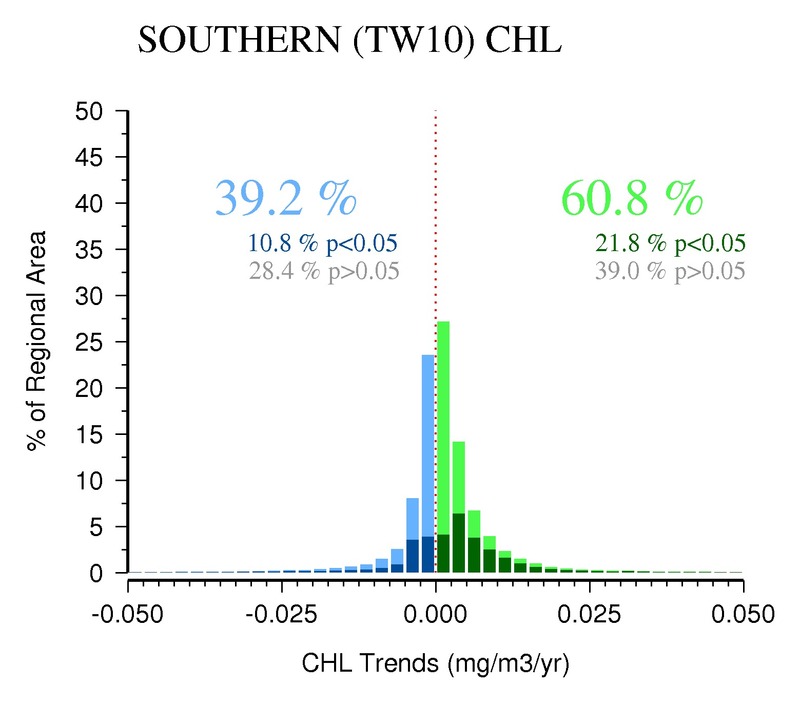
(2008-2012) | 10-Year
(2003-2012) | 15-Year
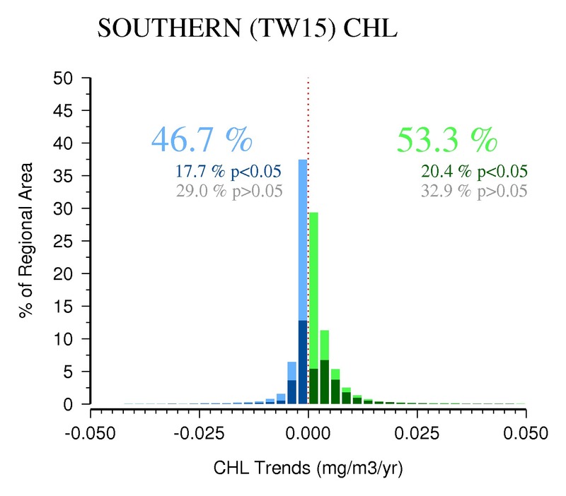
(1998-2012) |
20-Year
(1993-2012) | 25-Year
(1988-2012) | 30-Year
(1983-2012) |
Area (%) w/ Increasing CHL Trends
( p<0.05 ) |
45.8%
( 9.9% ) |
60.8%
( 21.8% ) |
53.3%
( 20.4% ) |
|
|
|
Area (%) w/ Decreasing CHL Trends
( p<0.05 ) |
54.2%
( 19.5% ) |
39.2%
( 10.8% ) |
46.7%
( 17.7% ) |
|
|
|
| |
> 0.50 mg/m3/decade (increasing)
( p<0.05 )
|
5.3%
( 2.5% ) |
0.7%
( 0.4% ) |
0.3%
( 0.2% ) |
|
|
|
0.10 to 0.50 mg/m3/decade (increasing)
( p<0.05 )
|
15.4%
( 5.1% ) |
7.6%
( 4.8% ) |
3.8%
( 2.7% ) |
|
|
|
0.01 to 0.10 mg/m3/decade (increasing)
( p<0.05 )
|
20.6%
( 2.2% ) |
41.2%
( 16.3% ) |
34.4%
( 16.9% ) |
|
|
|
0.00 to 0.01 mg/m3/decade (increasing)
( p<0.05 )
|
4.4%
( 0.1% ) |
11.3%
( 0.3% ) |
14.9%
( 0.6% ) |
|
|
|
0.00 to -0.01 mg/m3/decade (decreasing)
( p<0.05 )
|
4.2%
( 0.0% ) |
10.3%
( 0.5% ) |
16.5%
( 2.1% ) |
|
|
|
-0.01 to -0.10 mg/m3/decade (decreasing)
( p<0.05 )
|
35.3%
( 11.8% ) |
24.7%
( 8.2% ) |
28.7%
( 15.0% ) |
|
|
|
-0.10 to -0.50 mg/m3/decade (decreasing)
( p<0.05 )
|
11.8%
( 6.2% ) |
3.9%
( 1.9% ) |
1.4%
( 0.5% ) |
|
|
|
> -0.50 mg/m3/decade (decreasing)
( p<0.05 )
|
2.8%
( 1.5% ) |
0.3%
( 0.2% ) |
0.1%
( 0.1% ) |
|
|
|


