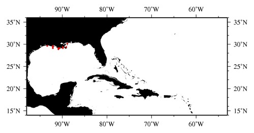
|

* The stations below are sorted by date, then by time, and then by "Orig-Identifier". As time over-rides the Orig-Identifier sequencing,
missing or incorrect times may create incorrect "Orig-Identifier" and/or station sorting.
* * B= Total Biomass, Z = Zooplankton, P = Phytoplankton
| YYYY-MM-DD* | Time (GMT)* | Longitude | Latitude | Station (Orig-Identifier*) | Station (Parameter List**) |
|---|---|---|---|---|---|
| 1987-07-06 | 16.33 | -93.3667 | 29.7333 | B-- | |
| 1987-07-06 | 16.87 | -93.3667 | 29.7500 | B-- | |
| 1987-07-06 | 18.27 | -90.9667 | 28.9367 | B-- | |
| 1987-07-06 | 18.62 | -89.0717 | 29.4133 | B-- | |
| 1987-07-06 | 19.02 | -90.9817 | 29.0167 | B-- | |
| 1987-07-06 | 20.00 | -89.1600 | 29.4483 | B-- | |
| 1987-07-06 | 20.03 | -90.9708 | 29.1583 | B-- | |
| 1987-07-08 | 15.58 | -88.8612 | 30.0533 | B-- | |
| 1987-07-08 | 16.13 | -88.8567 | 30.0550 | B-- | |
| 1987-07-09 | 17.08 | -88.8467 | 30.0617 | B-- | |
| 1987-07-09 | 15.92 | -89.9328 | 29.2717 | B-- | |
| 1987-07-09 | 16.98 | -92.1583 | 29.1583 | B-- | |
| 1987-07-09 | 16.82 | -89.9033 | 29.2508 | B-- | |
| 1987-07-09 | 17.53 | -89.8783 | 29.2320 | B-- | |
| 1987-07-09 | 17.90 | -90.5950 | 29.0745 | B-- | |
| 1987-07-09 | 18.50 | -92.1133 | 29.3217 | B-- | |
| 1987-07-09 | 18.33 | -90.5950 | 29.0338 | B-- | |
| 1987-07-09 | 19.25 | -90.5950 | 29.0083 | B-- | |
| 1987-07-09 | 20.00 | -92.0300 | 29.5667 | B-- |
| Sub-Collection: SEAMAP |
COPEPOD Web v10.1 [ 2010-Dec ] |
