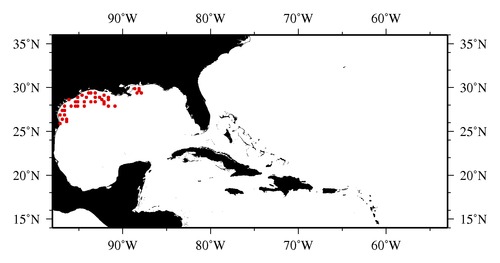
|

* The stations below are sorted by date, then by time, and then by "Orig-Identifier". As time over-rides the Orig-Identifier sequencing,
missing or incorrect times may create incorrect "Orig-Identifier" and/or station sorting.
* * B= Total Biomass, Z = Zooplankton, P = Phytoplankton
| YYYY-MM-DD* | Time (GMT)* | Longitude | Latitude | Station (Orig-Identifier*) | Station (Parameter List**) |
|---|---|---|---|---|---|
| 2005-10-11 | 21.33 | -96.4955 | 26.4958 | B-- | |
| 2005-10-12 | 08.22 | -96.4963 | 26.0330 | B-- | |
| 2005-10-12 | 12.08 | -97.0005 | 25.9943 | B-- | |
| 2005-10-13 | 12.05 | -96.9957 | 26.4962 | B-- | |
| 2005-10-14 | 15.20 | -96.6940 | 26.9067 | B-- | |
| 2005-10-14 | 22.55 | -97.2183 | 26.9850 | B-- | |
| 2005-10-16 | 23.05 | -96.9967 | 27.4898 | B-- | |
| 2005-10-17 | 12.68 | -96.5032 | 27.4953 | B-- | |
| 2005-10-18 | 13.90 | -96.5492 | 27.9790 | B-- | |
| 2005-10-19 | 10.55 | -95.9705 | 27.9985 | B-- | |
| 2005-10-20 | 00.60 | -95.4985 | 27.9998 | B-- | |
| 2005-10-21 | 23.32 | -96.0080 | 28.5048 | B-- | |
| 2005-10-22 | 09.50 | -95.4952 | 28.4942 | B-- | |
| 2005-10-22 | 13.80 | -95.0008 | 28.4973 | B-- | |
| 2005-10-23 | 14.68 | -95.0022 | 28.9927 | B-- | |
| 2005-10-23 | 23.63 | -94.5022 | 29.0028 | B-- | |
| 2005-10-26 | 10.67 | -94.4998 | 28.4943 | B-- | |
| 2005-10-27 | 09.62 | -95.0000 | 27.9950 | B-- | |
| 2005-10-27 | 17.47 | -94.4863 | 27.9888 | B-- | |
| 2005-10-28 | 22.90 | -94.0008 | 28.9698 | B-- | |
| 2005-10-29 | 12.37 | -93.9960 | 29.4943 | B-- | |
| 2005-10-29 | 20.92 | -93.5173 | 29.4362 | B-- | |
| 2005-10-30 | 03.57 | -93.0048 | 29.4992 | B-- | |
| 2005-11-01 | 00.08 | -93.5025 | 28.4915 | B-- | |
| 2005-11-03 | 05.52 | -92.4307 | 28.5185 | B-- | |
| 2005-11-03 | 14.00 | -93.0007 | 28.4967 | B-- | |
| 2005-11-03 | 20.37 | -93.0077 | 28.9968 | B-- | |
| 2005-11-04 | 23.40 | -92.5363 | 28.9995 | B-- | |
| 2005-11-05 | 12.80 | -92.0012 | 29.0012 | B-- | |
| 2005-11-06 | 03.28 | -92.0002 | 28.4983 | B-- | |
| 2005-11-06 | 09.83 | -91.5065 | 28.9367 | B-- | |
| 2005-11-07 | 01.53 | -91.5087 | 28.5027 | B-- | |
| 2005-11-07 | 09.90 | -92.0000 | 28.0017 | B-- | |
| 2005-11-08 | 01.57 | -91.5053 | 27.9947 | B-- | |
| 2005-11-08 | 05.40 | -90.9953 | 27.9947 | B-- | |
| 2005-11-09 | 01.42 | -87.9983 | 29.2522 | B-- | |
| 2005-11-09 | 03.97 | -88.0457 | 29.5023 | B-- | |
| 2005-11-13 | 02.52 | -88.1400 | 29.9987 | B-- | |
| 2005-11-13 | 22.30 | -88.4995 | 29.4977 | B-- | |
| 2005-11-14 | 22.90 | -88.5008 | 29.9683 | B-- |
| Sub-Collection: SEAMAP |
COPEPOD Web v10.1 [ 2010-Dec ] |
