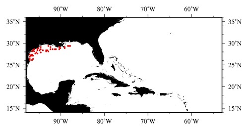
|

* The stations below are sorted by date, then by time, and then by "Orig-Identifier". As time over-rides the Orig-Identifier sequencing,
missing or incorrect times may create incorrect "Orig-Identifier" and/or station sorting.
* * B= Total Biomass, Z = Zooplankton, P = Phytoplankton
| YYYY-MM-DD* | Time (GMT)* | Longitude | Latitude | Station (Orig-Identifier*) | Station (Parameter List**) |
|---|---|---|---|---|---|
| 1996-10-12 | 01.43 | -96.5003 | 26.0332 | B-- | |
| 1996-10-12 | 09.60 | -97.0007 | 26.0005 | B-- | |
| 1996-10-13 | 06.63 | -97.0245 | 26.4998 | B-- | |
| 1996-10-13 | 14.13 | -96.4950 | 26.4995 | B-- | |
| 1996-10-15 | 02.62 | -97.1943 | 26.9998 | B-- | |
| 1996-10-16 | 02.30 | -96.5163 | 27.4960 | B-- | |
| 1996-10-16 | 10.38 | -96.4895 | 27.0027 | B-- | |
| 1996-10-16 | 12.65 | -96.6923 | 27.0015 | B-- | |
| 1996-10-16 | 16.18 | -96.9580 | 27.0102 | B-- | |
| 1996-10-17 | 04.42 | -97.0103 | 27.4928 | B-- | |
| 1996-10-18 | 01.88 | -95.9980 | 27.5815 | B-- | |
| 1996-10-19 | 02.42 | -96.5030 | 28.0023 | B-- | |
| 1996-10-19 | 11.77 | -96.3003 | 28.3023 | B-- | |
| 1996-10-19 | 21.13 | -96.0013 | 28.5018 | B-- | |
| 1996-10-20 | 02.23 | -96.0027 | 28.0013 | B-- | |
| 1996-10-20 | 06.88 | -95.5427 | 27.9828 | B-- | |
| 1996-10-20 | 20.05 | -95.4997 | 27.7492 | B-- | |
| 1996-10-21 | 11.48 | -95.4488 | 28.4770 | B-- | |
| 1996-10-23 | 02.47 | -95.4978 | 28.7472 | B-- | |
| 1996-10-23 | 10.37 | -95.0003 | 28.9998 | B-- | |
| 1996-10-26 | 03.48 | -94.5352 | 29.0572 | B-- | |
| 1996-10-26 | 18.37 | -94.5015 | 28.5013 | B-- | |
| 1996-10-27 | 03.67 | -94.9943 | 28.4852 | B-- | |
| 1996-10-27 | 17.78 | -94.5017 | 27.9640 | B-- | |
| 1996-10-28 | 09.55 | -94.0007 | 28.4988 | B-- | |
| 1996-10-29 | 03.55 | -93.4432 | 28.0277 | B-- | |
| 1996-10-30 | 12.68 | -93.4705 | 28.4655 | B-- | |
| 1996-11-01 | 07.47 | -92.9668 | 29.4990 | B-- | |
| 1996-11-02 | 04.75 | -92.4580 | 29.1197 | B-- | |
| 1996-11-04 | 02.72 | -93.0000 | 28.4982 | B-- | |
| 1996-11-04 | 09.63 | -92.9965 | 28.0015 | B-- | |
| 1996-11-04 | 22.02 | -92.4638 | 28.5360 | B-- | |
| 1996-11-05 | 03.08 | -91.9587 | 28.5425 | B-- | |
| 1996-11-06 | 05.17 | -91.4467 | 28.5667 | B-- | |
| 1996-11-06 | 10.82 | -91.0033 | 28.5012 | B-- | |
| 1996-11-13 | 16.70 | -90.4967 | 28.5098 | B-- | |
| 1996-11-14 | 08.82 | -90.4985 | 29.0003 | B-- | |
| 1996-11-14 | 13.75 | -90.0675 | 28.9805 | B-- | |
| 1996-11-20 | 10.37 | -89.0408 | 28.9687 | B-- | |
| 1996-11-20 | 12.47 | -89.0030 | 29.0893 | B-- | |
| 1996-11-21 | 10.05 | -87.9997 | 29.4953 | B-- | |
| 1996-11-21 | 12.83 | -88.0043 | 29.2508 | B-- | |
| 1996-11-21 | 17.85 | -88.4673 | 29.2503 | B-- |
| Sub-Collection: SEAMAP |
COPEPOD Web v10.1 [ 2010-Dec ] |
