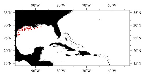
|

* The stations below are sorted by date, then by time, and then by "Orig-Identifier". As time over-rides the Orig-Identifier sequencing,
missing or incorrect times may create incorrect "Orig-Identifier" and/or station sorting.
* * B= Total Biomass, Z = Zooplankton, P = Phytoplankton
| YYYY-MM-DD* | Time (GMT)* | Longitude | Latitude | Station (Orig-Identifier*) | Station (Parameter List**) |
|---|---|---|---|---|---|
| 1993-10-16 | 00.03 | -96.9933 | 26.4950 | B-- | |
| 1993-10-16 | 08.47 | -96.9967 | 26.0167 | B-- | |
| 1993-10-16 | 22.98 | -96.4985 | 26.4930 | B-- | |
| 1993-10-18 | 06.68 | -96.5717 | 27.0317 | B-- | |
| 1993-10-21 | 00.07 | -96.5050 | 28.0083 | B-- | |
| 1993-10-23 | 01.48 | -96.0060 | 27.9983 | B-- | |
| 1993-10-23 | 11.92 | -95.3697 | 28.0598 | B-- | |
| 1993-10-24 | 05.10 | -95.4818 | 28.5785 | B-- | |
| 1993-10-25 | 05.15 | -95.0062 | 28.3900 | B-- | |
| 1993-10-25 | 15.58 | -95.0053 | 27.9645 | B-- | |
| 1993-10-26 | 04.22 | -94.4970 | 27.9762 | B-- | |
| 1993-10-26 | 23.20 | -94.4650 | 28.4455 | B-- | |
| 1993-10-27 | 03.52 | -94.0075 | 28.4998 | B-- | |
| 1993-10-27 | 08.30 | -94.0018 | 28.9940 | B-- | |
| 1993-10-27 | 11.45 | -94.4843 | 28.9985 | B-- | |
| 1993-10-29 | 12.63 | -95.0997 | 29.0327 | B-- | |
| 1993-10-31 | 16.13 | -93.3635 | 29.0068 | B-- | |
| 1993-10-31 | 20.33 | -93.1067 | 28.8902 | B-- | |
| 1993-11-01 | 04.38 | -93.4013 | 28.5177 | B-- | |
| 1993-11-01 | 15.60 | -92.9653 | 28.6645 | B-- | |
| 1993-11-01 | 21.07 | -92.8862 | 28.1765 | B-- | |
| 1993-11-03 | 13.27 | -92.4928 | 28.5640 | B-- | |
| 1993-11-03 | 19.67 | -92.0323 | 28.5338 | B-- | |
| 1993-11-04 | 18.47 | -92.7320 | 29.5505 | B-- | |
| 1993-11-05 | 03.47 | -92.0215 | 29.0285 | B-- | |
| 1993-11-05 | 11.88 | -92.4992 | 28.6663 | B-- | |
| 1993-11-08 | 01.12 | -91.5053 | 28.4903 | B-- | |
| 1993-11-10 | 07.67 | -90.4980 | 28.5017 | B-- | |
| 1993-11-10 | 23.63 | -89.4988 | 29.0008 | B-- | |
| 1993-11-14 | 22.42 | -87.9990 | 29.4927 | B-- |
| Sub-Collection: SEAMAP |
COPEPOD Web v10.1 [ 2010-Dec ] |
