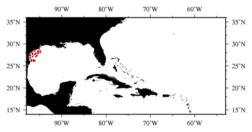
|

* The stations below are sorted by date, then by time, and then by "Orig-Identifier". As time over-rides the Orig-Identifier sequencing,
missing or incorrect times may create incorrect "Orig-Identifier" and/or station sorting.
* * B= Total Biomass, Z = Zooplankton, P = Phytoplankton
| YYYY-MM-DD* | Time (GMT)* | Longitude | Latitude | Station (Orig-Identifier*) | Station (Parameter List**) |
|---|---|---|---|---|---|
| 2010-09-01 | 17.32 | -96.0240 | 26.0487 | B-- | |
| 2010-09-01 | 20.98 | -96.4243 | 26.1040 | B-- | |
| 2010-09-02 | 02.13 | -96.9318 | 26.1233 | B-- | |
| 2010-09-02 | 09.37 | -96.9915 | 26.4948 | B-- | |
| 2010-09-02 | 15.72 | -96.4988 | 26.4978 | B-- | |
| 2010-09-02 | 23.78 | -97.2027 | 26.9980 | B-- | |
| 2010-09-03 | 03.97 | -96.6722 | 27.0243 | B-- | |
| 2010-09-03 | 13.42 | -95.9978 | 27.0010 | B-- | |
| 2010-09-04 | 09.00 | -97.0482 | 27.4470 | B-- | |
| 2010-09-04 | 16.12 | -96.5023 | 27.5017 | B-- | |
| 2010-09-04 | 23.45 | -96.0057 | 27.5543 | B-- | |
| 2010-09-05 | 03.52 | -95.5062 | 27.5000 | B-- | |
| 2010-09-05 | 06.20 | -95.4953 | 27.7527 | B-- | |
| 2010-09-05 | 16.37 | -95.9968 | 27.9992 | B-- | |
| 2010-09-05 | 19.67 | -96.5015 | 28.0000 | B-- | |
| 2010-09-06 | 04.28 | -96.0168 | 28.4788 | B-- | |
| 2010-09-06 | 09.98 | -95.4880 | 28.4702 | B-- | |
| 2010-09-13 | 19.17 | -95.0062 | 28.9972 | B-- | |
| 2010-09-13 | 22.70 | -94.9982 | 28.4972 | B-- | |
| 2010-09-14 | 03.62 | -95.4988 | 28.0008 | B-- | |
| 2010-09-14 | 07.15 | -94.9955 | 28.0032 | B-- |
| Sub-Collection: SEAMAP |
COPEPOD Web v10.1 [ 2010-Dec ] |
