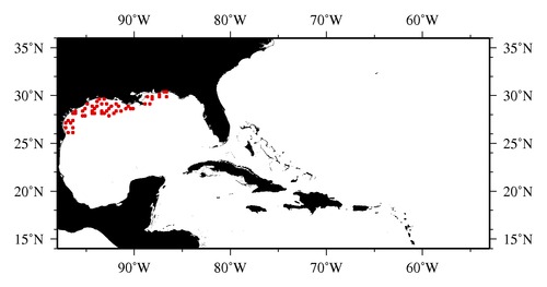
|

* The stations below are sorted by date, then by time, and then by "Orig-Identifier". As time over-rides the Orig-Identifier sequencing,
missing or incorrect times may create incorrect "Orig-Identifier" and/or station sorting.
* * B= Total Biomass, Z = Zooplankton, P = Phytoplankton
| YYYY-MM-DD* | Time (GMT)* | Longitude | Latitude | Station (Orig-Identifier*) | Station (Parameter List**) |
|---|---|---|---|---|---|
| 2009-06-09 | 07.48 | -88.5067 | 29.9487 | B-- | |
| 2009-06-09 | 18.32 | -88.0362 | 29.9878 | B-- | |
| 2009-06-11 | 09.93 | -88.0422 | 29.5118 | B-- | |
| 2009-06-11 | 17.52 | -88.4905 | 29.2168 | B-- | |
| 2009-06-12 | 04.78 | -88.9885 | 29.0122 | B-- | |
| 2009-06-13 | 20.50 | -96.4992 | 26.5033 | B-- | |
| 2009-06-14 | 04.88 | -96.4895 | 26.0297 | B-- | |
| 2009-06-14 | 11.52 | -96.9975 | 26.0005 | B-- | |
| 2009-06-15 | 03.47 | -97.0023 | 26.5048 | B-- | |
| 2009-06-15 | 16.33 | -96.6612 | 27.0013 | B-- | |
| 2009-06-16 | 02.98 | -97.1980 | 27.0045 | B-- | |
| 2009-06-16 | 18.42 | -96.9945 | 27.4962 | B-- | |
| 2009-06-17 | 02.42 | -96.4988 | 27.4988 | B-- | |
| 2009-06-17 | 23.17 | -96.4968 | 28.0013 | B-- | |
| 2009-06-18 | 09.82 | -96.0780 | 28.0280 | B-- | |
| 2009-06-19 | 12.85 | -96.0122 | 28.4772 | B-- | |
| 2009-06-23 | 07.70 | -94.9990 | 29.0007 | B-- | |
| 2009-06-23 | 14.52 | -94.4982 | 28.9978 | B-- | |
| 2009-06-24 | 15.17 | -95.4845 | 28.4838 | B-- | |
| 2009-06-25 | 02.73 | -95.4822 | 27.9853 | B-- | |
| 2009-06-25 | 14.37 | -95.0017 | 27.9890 | B-- | |
| 2009-06-26 | 00.72 | -95.0010 | 28.5005 | B-- | |
| 2009-06-26 | 07.97 | -94.4998 | 28.4992 | B-- | |
| 2009-06-27 | 01.75 | -94.0133 | 28.5007 | B-- | |
| 2009-06-27 | 15.07 | -94.4877 | 28.0095 | B-- | |
| 2009-06-27 | 23.95 | -94.0033 | 28.0042 | B-- | |
| 2009-06-28 | 08.20 | -93.4980 | 28.0122 | B-- | |
| 2009-06-28 | 19.57 | -93.0015 | 28.0078 | B-- | |
| 2009-06-29 | 02.65 | -92.5243 | 27.9917 | B-- | |
| 2009-06-29 | 14.62 | -92.9823 | 28.4920 | B-- | |
| 2009-06-30 | 01.98 | -93.4990 | 28.4918 | B-- | |
| 2009-06-30 | 13.92 | -93.9880 | 28.9902 | B-- | |
| 2009-07-01 | 15.12 | -93.9940 | 29.4858 | B-- | |
| 2009-07-01 | 18.90 | -93.5470 | 29.5330 | B-- | |
| 2009-07-02 | 22.35 | -93.4967 | 29.0210 | B-- | |
| 2009-07-07 | 05.83 | -92.9945 | 29.0020 | B-- | |
| 2009-07-07 | 23.90 | -93.0012 | 29.5008 | B-- | |
| 2009-07-08 | 10.08 | -92.4652 | 28.9963 | B-- | |
| 2009-07-09 | 03.82 | -92.5305 | 28.5052 | B-- | |
| 2009-07-10 | 01.70 | -91.9825 | 29.0182 | B-- | |
| 2009-07-10 | 08.13 | -91.5272 | 28.9620 | B-- | |
| 2009-07-10 | 16.95 | -91.9975 | 28.4982 | B-- | |
| 2009-07-11 | 02.63 | -92.0133 | 28.0077 | B-- | |
| 2009-07-11 | 12.30 | -91.4948 | 28.4983 | B-- | |
| 2009-07-12 | 11.30 | -90.9997 | 28.5008 | B-- | |
| 2009-07-13 | 14.23 | -90.0055 | 28.5017 | B-- | |
| 2009-07-13 | 19.13 | -90.4938 | 28.5028 | B-- | |
| 2009-07-13 | 22.82 | -90.5487 | 28.8920 | B-- | |
| 2009-07-16 | 15.58 | -87.4865 | 29.9970 | B-- | |
| 2009-07-16 | 18.88 | -87.4960 | 30.2208 | B-- | |
| 2009-07-17 | 03.38 | -86.9907 | 30.3137 | B-- | |
| 2009-07-17 | 08.57 | -86.5135 | 30.3317 | B-- | |
| 2009-07-17 | 15.88 | -86.5117 | 29.9960 | B-- |
| Sub-Collection: SEAMAP |
COPEPOD Web v10.1 [ 2010-Dec ] |
