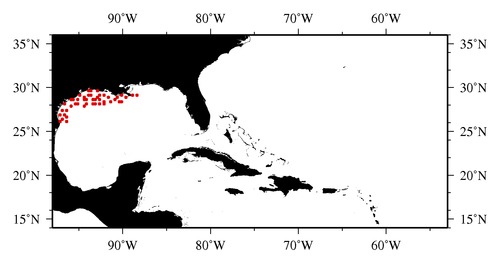
|

* The stations below are sorted by date, then by time, and then by "Orig-Identifier". As time over-rides the Orig-Identifier sequencing,
missing or incorrect times may create incorrect "Orig-Identifier" and/or station sorting.
* * B= Total Biomass, Z = Zooplankton, P = Phytoplankton
| YYYY-MM-DD* | Time (GMT)* | Longitude | Latitude | Station (Orig-Identifier*) | Station (Parameter List**) |
|---|---|---|---|---|---|
| 2008-06-14 | 03.53 | -88.4888 | 29.2425 | B-- | |
| 2008-06-14 | 10.52 | -88.9943 | 29.0327 | B-- | |
| 2008-06-16 | 06.98 | -96.4152 | 26.0433 | B-- | |
| 2008-06-16 | 13.92 | -96.4990 | 26.5042 | B-- | |
| 2008-06-17 | 02.07 | -97.0407 | 26.0057 | B-- | |
| 2008-06-17 | 10.73 | -96.7542 | 26.3707 | B-- | |
| 2008-06-18 | 19.23 | -96.6682 | 26.9887 | B-- | |
| 2008-06-20 | 00.03 | -96.9998 | 27.4948 | B-- | |
| 2008-06-20 | 07.47 | -97.1902 | 26.9847 | B-- | |
| 2008-06-20 | 17.63 | -96.4965 | 27.4940 | B-- | |
| 2008-06-21 | 20.57 | -95.9958 | 27.9972 | B-- | |
| 2008-06-22 | 01.80 | -96.5222 | 28.0507 | B-- | |
| 2008-06-23 | 12.30 | -95.9212 | 28.5077 | B-- | |
| 2008-06-23 | 18.38 | -95.5192 | 28.5868 | B-- | |
| 2008-06-26 | 13.02 | -95.0882 | 28.5075 | B-- | |
| 2008-06-26 | 19.38 | -94.9893 | 29.0138 | B-- | |
| 2008-06-28 | 04.40 | -95.4938 | 28.0008 | B-- | |
| 2008-06-28 | 14.85 | -95.0028 | 28.0015 | B-- | |
| 2008-06-28 | 19.15 | -94.4668 | 27.9728 | B-- | |
| 2008-06-29 | 14.25 | -94.0002 | 28.0052 | B-- | |
| 2008-06-29 | 20.22 | -93.4837 | 28.0037 | B-- | |
| 2008-06-30 | 00.02 | -93.0123 | 28.0067 | B-- | |
| 2008-06-30 | 12.08 | -93.4962 | 28.5120 | B-- | |
| 2008-07-01 | 06.07 | -94.4593 | 28.6047 | B-- | |
| 2008-07-01 | 13.00 | -94.4983 | 28.9975 | B-- | |
| 2008-07-02 | 01.07 | -94.0095 | 28.5218 | B-- | |
| 2008-07-02 | 11.90 | -93.9915 | 29.0033 | B-- | |
| 2008-07-06 | 01.72 | -93.9567 | 29.5107 | B-- | |
| 2008-07-06 | 05.92 | -93.5345 | 29.5345 | B-- | |
| 2008-07-06 | 09.05 | -92.9968 | 29.5013 | B-- | |
| 2008-07-07 | 09.57 | -92.5198 | 29.0493 | B-- | |
| 2008-07-07 | 14.13 | -92.9965 | 28.9972 | B-- | |
| 2008-07-07 | 20.92 | -93.5228 | 29.0397 | B-- | |
| 2008-07-09 | 10.52 | -93.0385 | 28.5722 | B-- | |
| 2008-07-09 | 18.00 | -92.5067 | 28.5088 | B-- | |
| 2008-07-10 | 10.12 | -92.5185 | 28.0638 | B-- | |
| 2008-07-10 | 15.77 | -92.0025 | 28.4990 | B-- | |
| 2008-07-11 | 02.98 | -92.0028 | 28.0032 | B-- | |
| 2008-07-11 | 16.58 | -91.4705 | 28.4947 | B-- | |
| 2008-07-12 | 12.15 | -92.0148 | 29.0085 | B-- | |
| 2008-07-12 | 16.30 | -91.5207 | 28.9813 | B-- | |
| 2008-07-13 | 15.68 | -90.9393 | 28.5378 | B-- | |
| 2008-07-14 | 10.55 | -90.0573 | 28.4603 | B-- | |
| 2008-07-14 | 16.08 | -90.4918 | 28.4637 | B-- | |
| 2008-07-14 | 21.87 | -90.6417 | 28.8910 | B-- | |
| 2008-07-15 | 16.08 | -90.0197 | 29.0065 | B-- | |
| 2008-07-16 | 08.80 | -89.5660 | 28.9803 | B-- |
| Sub-Collection: SEAMAP |
COPEPOD Web v10.1 [ 2010-Dec ] |
