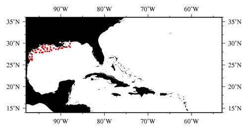
|

* The stations below are sorted by date, then by time, and then by "Orig-Identifier". As time over-rides the Orig-Identifier sequencing,
missing or incorrect times may create incorrect "Orig-Identifier" and/or station sorting.
* * B= Total Biomass, Z = Zooplankton, P = Phytoplankton
| YYYY-MM-DD* | Time (GMT)* | Longitude | Latitude | Station (Orig-Identifier*) | Station (Parameter List**) |
|---|---|---|---|---|---|
| 2002-10-13 | 06.40 | -96.5230 | 26.4728 | B-- | |
| 2002-10-13 | 10.43 | -96.5205 | 26.0268 | B-- | |
| 2002-10-14 | 04.45 | -97.0638 | 26.0132 | B-- | |
| 2002-10-14 | 09.57 | -96.9980 | 26.4995 | B-- | |
| 2002-10-15 | 11.83 | -96.5007 | 26.9963 | B-- | |
| 2002-10-15 | 18.62 | -97.0022 | 26.9923 | B-- | |
| 2002-10-17 | 09.02 | -96.5617 | 27.3505 | B-- | |
| 2002-10-17 | 15.92 | -96.9033 | 27.5828 | B-- | |
| 2002-10-19 | 22.43 | -95.9958 | 28.4378 | B-- | |
| 2002-10-20 | 05.77 | -96.3850 | 28.0077 | B-- | |
| 2002-10-20 | 16.13 | -95.9513 | 27.8967 | B-- | |
| 2002-10-21 | 10.88 | -95.5242 | 27.8908 | B-- | |
| 2002-10-22 | 21.15 | -95.3813 | 28.5848 | B-- | |
| 2002-10-23 | 10.58 | -95.0448 | 28.5373 | B-- | |
| 2002-10-23 | 18.15 | -94.6052 | 28.3282 | B-- | |
| 2002-10-24 | 03.17 | -94.4698 | 27.9788 | B-- | |
| 2002-10-24 | 07.05 | -94.9112 | 27.9877 | B-- | |
| 2002-10-24 | 16.23 | -94.0247 | 27.9182 | B-- | |
| 2002-10-24 | 22.45 | -93.9688 | 28.5042 | B-- | |
| 2002-10-28 | 09.17 | -94.4988 | 29.0082 | B-- | |
| 2002-10-29 | 10.10 | -94.0048 | 28.9912 | B-- | |
| 2002-10-30 | 03.37 | -94.0285 | 29.4735 | B-- | |
| 2002-10-30 | 06.52 | -93.5227 | 29.5025 | B-- | |
| 2002-10-30 | 22.17 | -93.5552 | 29.0570 | B-- | |
| 2002-11-01 | 00.72 | -93.5018 | 28.1198 | B-- | |
| 2002-11-01 | 12.18 | -93.0847 | 28.5122 | B-- | |
| 2002-11-01 | 22.50 | -93.0792 | 28.8907 | B-- | |
| 2002-11-02 | 07.20 | -92.9825 | 29.5360 | B-- | |
| 2002-11-02 | 23.72 | -92.4670 | 29.1463 | B-- | |
| 2002-11-03 | 15.45 | -92.4907 | 28.6013 | B-- | |
| 2002-11-03 | 23.47 | -93.0087 | 28.2372 | B-- | |
| 2002-11-04 | 12.70 | -92.6483 | 28.0817 | B-- | |
| 2002-11-05 | 06.38 | -92.0053 | 28.4937 | B-- | |
| 2002-11-05 | 19.25 | -91.5995 | 28.9953 | B-- | |
| 2002-11-07 | 17.15 | -91.0597 | 28.5408 | B-- | |
| 2002-11-08 | 14.18 | -90.4033 | 28.9218 | B-- | |
| 2002-11-08 | 19.30 | -90.5272 | 28.5633 | B-- | |
| 2002-11-09 | 11.82 | -89.9817 | 28.8905 | B-- | |
| 2002-11-10 | 14.18 | -89.5370 | 28.9672 | B-- | |
| 2002-11-10 | 19.12 | -88.9730 | 29.0080 | B-- | |
| 2002-11-14 | 17.35 | -88.5022 | 29.2002 | B-- | |
| 2002-11-14 | 21.72 | -87.9957 | 29.2278 | B-- | |
| 2002-11-15 | 16.68 | -88.0348 | 29.4398 | B-- | |
| 2002-11-15 | 21.27 | -87.9995 | 29.9963 | B-- |
| Sub-Collection: SEAMAP |
COPEPOD Web v10.1 [ 2010-Dec ] |
