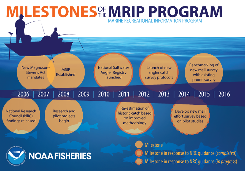
Program Evolution

The Magnuson Fishery Conservation and Management Act of 1976 (MFCMA - Public Law 94-265) mandated a national program for management of fishery resources in the Exclusive Economic Zone (EEZ), which ranges from 3 to 200 miles from shore. The MFCMA also requires that fishery management plans for the EEZ consider harvest data for both recreational and commercial fisheries. The Marine Recreational Fishery Statistics Survey (MRFSS) was established as a national program in 1979 to provide a reliable database for estimating the impact of marine recreational fishing on marine resources. In 2008, MRFSS was formally replaced with the improved Marine Recreational Information Program (MRIP). 

The MRFSS data collection methodology consisted of two independent, but complementary, surveys: a telephone survey of households and an intercept survey of anglers at fishing access sites. Methodological studies conducted in the 1970's showed that a telephone survey could be used to collect reliable data on recreational fishing activity, including number of trips taken, type of access (shore, boat), and dates of the trips, if the recall period was no longer than 2 months.
 
Information about the fish caught on these fishing trips, such as the species of fish, and the number and size of the fish caught were obtained from anglers intercepted and interviewed at fishing access sites. The data from the two independent surveys were combined to produce estimates of total recreational fishing effort, catch and participation.

The program of surveys has been conducted annually by NOAA Fisheries since then, with survey changes intended to improve the quality and coverage of the surveys over the years. This timeline will describe the major changes to the surveys designs and coverage. Additionally, the timeline lists other major milestones and events in collecting recreational fishing data. 


1979 - 1989


Program

  • 1979/1981 - The Access-Point-Angler-Intercept-Survey (APAIS) and Coastal Household Telephone Survey (CHTS) were both initiated in 1979 along the Atlantic and Gulf of Mexico coasts, results of the survey and estimates produced using this data are available beginning in 1981.
  • 1986 - The Large Pelagic Survey (LPS) was initiated from Virginia through Maine.

Coverage

  • March 1981 - APAIS and CHTS implemented from Massachusetts to Texas and on Pacific Coast.
  • May 1981 - APAIS implemented in Maine and New Hampshire.
  • 1982 - Due to the high costs to sample during very low fishing activity, APAIS and CHTS sampling was conducted from March through December each year from Maine to Georgia, but all 12 months from Florida to Texas.
  • 1985 - Sampling in Jan/Feb (Wave 1) was initiated in Georgia to better evaluate the fishing activity and catches during that period in the Southeast region.
  • 1986 - Texas discontinued participation in all MRFSS surveys, in lieu of state designed programs.
  • 1986 - Party Boats (also known as Head Boats) were eliminated from the APAIS in the Southeast Region (NC to LA).
  • 1986 - LPS implemented from Virginia through Maine.
  • 1987 - APAIS and CHTS sampling in Wave 6 (Nov/Dec) was eliminated in Maine and New Hampshire due to very low fishing activity, low fishery catches, and high sampling cost.
  • 1988 - APAIS and CHTS Sampling in Wave 1 (Jan/Feb) was initiated in North Carolina to re-evaluate the fishing activity and catches during that period.

Design & Methods

  • 1981 - APAIS sampling was stratified by state, fishing mode (Beach/Bank Shore, Man-made Shore, Private or Rental Boat, or Party or Charter Boat).
  • 1981 - APAIS had a 2-month sampling periods, referred to as Waves.
  • 1981 - CHTS sampling was stratified by state, county, and two-month reference period (wave). Sampling is without replacement within strata (state/county/wave), as well as among strata within a year.
  • 1981 - CHTS had a 2-week sampling period (last week in wave through first week of following wave).
  • 1986 - APAIS shore and Beach/bank modes were combined into a single sampling and estimation mode (Shore).
  • 1986 - LPS implemented with 3 parts: a dockside mark-recapture survey, a telephone survey, and an access-point intercept survey.  Data from the 3 surveys were combined to produce total annual recreational landings of Atlantic bluefin tuna and other associated large pelagic species. 
  • 1987 - APAIS sampling in West Florida (Monroe - Escambia county) was stratified to increase sample size in Monroe county in Wave 1, and in the western panhandle (Escambia to Bay county) in Waves 3-5. Catch and effort estimates were generated for these regions separate from the rest of West Florida, then aggregated to report the 'state' totals for all of West Florida.
  • 1988 - The APAIS inland fishing area response was further detailed to allow identification of fishing in specific and significant estuaries along the Atlantic and Gulf coasts, such as Chesapeake Bay, Long Island Sound, and Tampa Bay. These specific areas are coded in the trip data files but estimates continued to be produced only at the collapsed Inland stratification. Use of post-stratification or domain estimation techniques allow estimates for these specific Inland water bodies to be produced.
  • 1988 - For the latter half of 1988, for CHTS in the Southeast region (NC to LA), the 2-month waves were split into single month waves. CHTS sampling, as well as catch and effort estimates, were stratified by month to produce independent one-month estimates, which were then aggregated to report bi-monthly Wave estimates.

1990 - 1994


Program

  • 1990 - Estimation work previously performed by a contractor (1979 - 1989) was moved to NOAA Fisheries. Statisticians were hired to assume responsibility for these tasks.

Coverage

  • 1990 - APAIS and CHTS discontinued on Pacific Coast due to funding.
  • 1989 - Wave 1 APAIS and CHTS sampling in Georgia discontinued.
  • 1991 - Wave 1 APAIS and CHTS sampling in North Carolina was discontinued, when it was determined that the cost/benefit of sampling in Jan/Feb was not justified.
  • 1993 - APAIS and CHTS were re-implemented on the Pacific coast.

Design & Methods

  • 1990 - Changes were implemented to improve quality assurance and quality control for APAIS conduct and processing of APAIS and CHTS data. Regional representatives began supervising the work of APAIS interviewers and ensured proper conduct of APAIS sampling protocols.
  • 1991 - Questions were added to the APAIS interview to identify anglers interviewed from the same boat and to record how many anglers fished on each boat party.
  • 1991 - Shore mode APAIS sampling in NC reverted back to separate sampling and estimation of catch and effort for Beach/Bank Shore and Man-made Shore.
  • 1992 - LPS increased sampling levels to generate seasonal estimates of bluefin tuna by size category (small and medium-sized) for in-season quota management.  Estimates of giant bluefin tuna, other tunas, billfishes, swordfish, and sharks were still produced annually at this time.

1995 - 1999


Program

  • 1997 - A pilot project, known as the Charter Boat Survey, was initiated to sample charter boat fishing effort via a weekly telephone survey. These efforts were led by NOAA Fisheries in cooperation with GSMFC and the state agencies of FL, AL, MS, and LA. This survey later became known as the Gulf For-Hire Survey (FHS).

Coverage

  • 1998 - The GulfFIN recreational fishery data collection program was implemented and APAIS conduct was transferred to state agency personnel from FL to LA.
  • 1996 - Wave 2 APAIS and CHTS sampling in NH and ME was eliminated.

Design & Methods

  • 1995 - New methods were implemented for estimating fishing effort from CHTS data. The new approach corrects for biases associated with item non-response (missing data). As a result, historical CHTS effort estimates increased approximately 5% in all states.   
  • 1995 - LPS was simplified to consist of only two components - a telephone survey of participating boats and a dockside intercept survey of boats returning from large pelagic fishing trips.  

2000 - 2004


Program

  • 2000 - The Charter Boat Survey (Gulf FHS) became the official method for estimating charter boat fishing effort in the Gulf of Mexico (West Florida to Louisiana).
  • 2000 - NOAA Fisheries collaborated with ACCSP and SC DNR to test a new For-Hire Survey (FHS) based on the Gulf Charter Boat Survey (Gulf FHS) design and compare it side-by-side with the CHTS and the SC Logbook reporting program as a method for estimating both charter boat and headboat fishing effort. The pilot study also compared APAIS/CHTS, APAIS/FHS, and SC logbook designs for estimating both total harvest and total catch by species. 
  • 2004 - NOAA Fisheries requested the National Academy of Sciences' National Research Council (NRC) conduct an independent scientific review of the government's data collection programs for monitoring the saltwater recreational fisheries of the U.S.

Coverage

  • 2000 - Puerto Rico and the U.S. Virgin Islands (USVI) implemented the APAIS and CHTS. USVI discontinued the surveys later the same year.
  • 2002 - ACCSP endorsed the implementation of the FHS on the Atlantic coast based on the results of the pilot study.
  • 2002 - Gulf FHS extended to include East Florida.
  • 2003 - APAIS, CHTS and FHS implemented on Oahu and Hawaii Islands.
  • 2003 - The FHS was fully implemented on the Atlantic Coast from Maine to Georgia starting in wave 2. First year outreach with charter boat and headboat captains along the coast helped to ensure successful full-year implementation in 2004.

Design & Methods

  • 2002 - Redesigned LPS telephone and intercept survey components were implemented  to generate monthly estimates of catches and landings of bluefin tuna by size category, as well as other large pelagic species.  
  • 2002 - Site clustering introduced for LPS dockside assignments.
  • 2003 - With the start of FHS pilot testing on the Atlantic coast, sample sizes in the Party-Charter APAIS sampling stratum were increased and stratified by boat type. This allowed for independent Charter and Party Boat effort and catch estimates.
  • 2004 - Collapsed Party-Charter boat mode is completely retired with the implementation of the FHS on the Atlantic Coast. Separate Charter and Party (Head) boat estimates are produced.

2005 - 2009


Program

  • 2005 - LPS survey management and estimation transferred from Sustainable Fisheries Office HMS Division to Office of Science and Technology Fisheries Statistics Division.  With this change, improvements were made to survey design, quality assurance and quality control protocols, and dissemination of information.  
  • 2006 - The NRC released its findings, recommending NOAA Fisheries and partnering state agencies dramatically redesign angler surveys to update data collection methods and analyses and foster positive relations with the recreational angling community and other stakeholders.
  • 2006 - NOAA Fisheries convenes a Management Framework Workshop of state and federal fisheries agency leaders, managers, and biologists to evaluate current data needs and review the NRC's findings. NOAA Fisheries is tasked with preparing, in cooperation with states and other partners, a blueprint for redesigning angler surveys by 2008. An executive steering committee is formed to shepherd the process.
  • 2007 - Magnuson-Stevens Fishery Conservation and Management Act (MSRA) was reauthorized. The legislation echoed many of the concerns raised by the NRC in calling for redesigned angler surveys. It included a requirement for NOAA Fisheries to develop a new National Saltwater Angler Registry as a key part of the broader redesign effort.
  • 2007 - NOAA Fisheries creates a Development Plan for improving recreational fisheries statistics. Teams of experts from NOAA Fisheries, state agencies, regional fisheries councils and commissions, and partner organizations are convened to deal with distinct aspects of the redesign process. This approach promotes a redesign process that is inclusive and transparent.
  • 2007 - NOAA Fisheries holds a workshop to catalogue research needs and identify priorities for survey redesign. A series of listening sessions are conducted with management and science partners in order to learn more about the regional fisheries unique characteristics and data needs.
  • 2008 - NOAA Fisheries finalizes a rule, developed by the National Saltwater Angler Registry Team and updated based on public comments, outlining the registry requirements and state exemptions. The Registry is designed to be a national database of recreational fishermen to be used in conducting surveys on recreational fishing catch and effort.
  • 2008 - In October, the Marine Recreational Information Program (MRIP) was established upon adoption of the Implementation Plan. The Executive Steering Committee (ESC) is supported by three teams: Operations (survey and information management improvements), Registry, and Communications and Education.
  • 2009 - NOAA Fisheries initiates a process of designating states as exempted states under the National Saltwater Angler Registry by entering into Memorandum of Agreement under which exempted states will provide data to NOAA Fisheries. Project updates are included in the 2009/2010 Implementation Plan Update.

Coverage

  • 2005 - APAIS and CHTS fully implemented in Hawaii. FHS limited to the Charter fleet on Hawaii and Maui only.
  • 2006 - Pacific discontinued APAIS and CHTS, in lieu of state designed programs.
  • 2006 - Hawaii discontinues the FHS.

2010 - 2014


Program

  • 2010 - National Saltwater Angler Registry goes into effect on January 1, 2010. NOAA Fisheries begins registering saltwater anglers. By Independence Day, more than half a million anglers have registered.
  • 2010 - The Information Management Team is established with the responsibility of improving information management, to allow the Operations Team to focus on survey improvements.
  • 2010 - MRIP pilot projects begin field testing methodologies for census and universal logbook reporting, among other innovations. Project updates are included in the 2010/2011 Implementation Plan Update and in the 2011 Report to Congress.
  • 2011 - Scientists, managers, and anglers convene for a Recreational Fisheries Data Timeliness Workshop aimed at expanding efforts and evaluating options to report out more timely recreational fishing catch and effort estimates. To learn more, watch a video about the Timeliness Workshop.
  • 2011 - By October, every state and territory in the nation except Hawaii, Puerto Rico and the U.S. Virgin Islands have implemented their own licensing or registration systems and established memoranda of agreements with NOAA Fisheries' National Saltwater Angler Registry to share license data. This means that most U.S. anglers are not required to register at the Federal level with the NSAR.
  • 2013 - The ESC Holds an Implementation Workshop to discuss strategies for implementing improved data collection designs.
  • 2014 - The Transition Team is established to manage the process of transitioning to improved survey methods, initially triggered by the release of the draft report testing a new fishing effort survey design.

Design & Methods

  • 2010 - To better track the financial and fishing impacts of the BP/Deepwater Horizon oil spill, NOAA Fisheries expands the telephone survey of for-hire operators in the Gulf of Mexico by increasing the sampling rate from 10% to 40%.
  • 2011 - Several high profile pilot studies are completed:
    • Testing a new sampling design for the APAIS in North Carolina.
    • Testing a Logbook Reporting Program in the Gulf of Mexico, which requires participants to provide weekly reports of all fishing activity and includes electronic logbook reporting.
    • Testing measurement error in CHTS and ALDS.
    • Testing a dual-frame mail survey for enhancing mail survey response rates.
    Project updates are included in the 2011/2012 Program Update.
  • 2012 - All 2004-2011 catch and effort estimates were produced using improved methods. The new methods address a major concern raised by the NRC's evaluation of MRFSS-that the catch estimation method was not correctly matched with the sampling design used gathering data, leading to potential bias in the estimates.
  • 2013 - Redesigned MRIP APAIS implemented March 2013, on Atlantic & Gulf Coasts, MA to LA (ME and NH included in May per annual schedule). The following changes in design were included:
    • Site-clusters (1-3 sites) sampled per assignment
    • Fixed time of day and duration - 6 hour intervals for sampling specified
    • Fixed date of sample assignment (no re-scheduling)
    • Fixed Mode of assignment – no alternate
    • No maximum number of angler interviews/all eligible anglers counted
  • May-Dec 2013 - Modifications made to sample allocations and distributions to improve APAIS assignment performance metrics (completed, completed with interviews, number interviews per assignment)
  • July 2013 - APAIS maximum cluster size reduced to 2 sites and Friday moved from WeekDay to WeekEnd day stratum – allowed more assignments to be allocated to high activity days and more time spent per site.
  • 2014 - Puerto Rico was transitioned from the MRFSS Intercept design to the MRIP APAIS design starting in Wave 1, 2014.
  • 2014 - APAIS discontinued in Louisiana.
  • May 2014 - APAIS mixed boat mode sampling replaces separate mode sampling assignments for Charter and Private/Rental Boats – improves efficiency of angler interviewing and increases chances for obtaining charter boat angler interviews.

2015 -


Design & Methods

  • 2015 - The fishing effort mail survey is conducted alongside the Coastal Household Telephone Survey on the Atlantic and Gulf coasts for benchmarking.
  • 2015 - NOAA Fisheries releases and initiates a three year plan for transitioning from the Coastal Household Telephone Survey to the mail-based Fishing Effort Survey. 
  • 2015 - APAIS re-implemented in Louisiana for benchmarking alongside the Louisiana Creel survey.