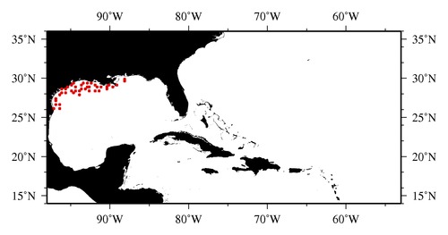
|

* The stations below are sorted by date, then by time, and then by "Orig-Identifier". As time over-rides the Orig-Identifier sequencing,
missing or incorrect times may create incorrect "Orig-Identifier" and/or station sorting.
* * B= Total Biomass, Z = Zooplankton, P = Phytoplankton
| YYYY-MM-DD* | Time (GMT)* | Longitude | Latitude | Station (Orig-Identifier*) | Station (Parameter List**) |
|---|---|---|---|---|---|
| 1993-06-20 | 13.03 | -88.0037 | 29.5028 | B-- | |
| 1993-06-21 | 01.85 | -89.0002 | 29.0003 | B-- | |
| 1993-06-22 | 17.70 | -96.4570 | 26.5183 | B-- | |
| 1993-06-23 | 00.33 | -96.4410 | 26.0223 | B-- | |
| 1993-06-24 | 00.22 | -97.0185 | 26.0593 | B-- | |
| 1993-06-24 | 14.53 | -96.9992 | 26.5055 | B-- | |
| 1993-06-25 | 18.95 | -96.9993 | 27.0025 | B-- | |
| 1993-06-26 | 02.22 | -96.9442 | 27.4662 | B-- | |
| 1993-06-27 | 11.40 | -96.4948 | 27.9878 | B-- | |
| 1993-06-28 | 12.32 | -96.0072 | 28.0192 | B-- | |
| 1993-06-28 | 17.55 | -96.0708 | 28.5275 | B-- | |
| 1993-06-29 | 01.02 | -95.5745 | 28.5038 | B-- | |
| 1993-06-29 | 16.92 | -95.5683 | 28.0002 | B-- | |
| 1993-06-30 | 00.30 | -95.4843 | 28.7592 | B-- | |
| 1993-06-30 | 15.12 | -94.9972 | 28.4990 | B-- | |
| 1993-07-01 | 19.38 | -93.9975 | 27.9970 | B-- | |
| 1993-07-02 | 15.00 | -94.5032 | 28.0053 | B-- | |
| 1993-07-02 | 18.45 | -94.4982 | 28.4987 | B-- | |
| 1993-07-03 | 03.98 | -94.8782 | 29.0713 | B-- | |
| 1993-07-03 | 06.68 | -94.4977 | 28.9973 | B-- | |
| 1993-07-03 | 09.88 | -94.5905 | 29.4290 | B-- | |
| 1993-07-05 | 11.63 | -93.5917 | 28.5105 | B-- | |
| 1993-07-06 | 23.63 | -93.5507 | 29.0570 | B-- | |
| 1993-07-07 | 14.57 | -92.8553 | 29.4528 | B-- | |
| 1993-07-07 | 20.33 | -93.3372 | 29.4207 | B-- | |
| 1993-07-09 | 16.82 | -92.6237 | 28.4938 | B-- | |
| 1993-07-10 | 03.65 | -93.9850 | 28.4983 | B-- | |
| 1993-07-10 | 15.00 | -93.0027 | 28.5002 | B-- | |
| 1993-07-10 | 18.37 | -92.9980 | 28.9973 | B-- | |
| 1993-07-10 | 23.85 | -92.5038 | 28.9973 | B-- | |
| 1993-07-11 | 19.85 | -92.4988 | 29.4763 | B-- | |
| 1993-07-12 | 21.10 | -91.9952 | 28.4928 | B-- | |
| 1993-07-13 | 17.30 | -91.4873 | 28.4972 | B-- | |
| 1993-07-13 | 22.30 | -91.5542 | 28.9260 | B-- | |
| 1993-07-14 | 01.20 | -91.9918 | 29.0033 | B-- | |
| 1993-07-14 | 16.82 | -91.0958 | 28.7540 | B-- | |
| 1993-07-16 | 15.92 | -90.4037 | 28.6005 | B-- | |
| 1993-07-16 | 23.27 | -90.3843 | 28.8708 | B-- | |
| 1993-07-17 | 15.28 | -90.2308 | 29.0195 | B-- | |
| 1993-07-17 | 21.28 | -89.5260 | 28.9773 | B-- | |
| 1993-07-21 | 23.70 | -88.0017 | 29.9990 | B-- |
| Sub-Collection: SEAMAP |
COPEPOD Web v10.1 [ 2010-Dec ] |
