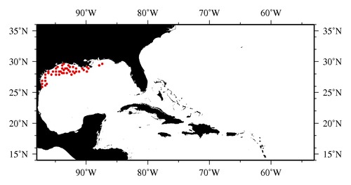
|

* The stations below are sorted by date, then by time, and then by "Orig-Identifier". As time over-rides the Orig-Identifier sequencing,
missing or incorrect times may create incorrect "Orig-Identifier" and/or station sorting.
* * B= Total Biomass, Z = Zooplankton, P = Phytoplankton
| YYYY-MM-DD* | Time (GMT)* | Longitude | Latitude | Station (Orig-Identifier*) | Station (Parameter List**) |
|---|---|---|---|---|---|
| 2011-06-25 | 22.40 | -96.5030 | 26.0527 | B-- | |
| 2011-06-26 | 04.20 | -97.0017 | 25.9972 | B-- | |
| 2011-06-26 | 11.20 | -97.0002 | 26.4947 | B-- | |
| 2011-06-26 | 15.43 | -96.4923 | 26.4788 | B-- | |
| 2011-06-27 | 12.47 | -97.1993 | 26.9948 | B-- | |
| 2011-06-27 | 18.17 | -96.6032 | 26.9720 | B-- | |
| 2011-06-29 | 00.62 | -96.5032 | 27.4997 | B-- | |
| 2011-06-29 | 17.25 | -96.5017 | 27.9947 | B-- | |
| 2011-06-30 | 00.97 | -96.0373 | 28.0202 | B-- | |
| 2011-06-30 | 06.48 | -95.5018 | 27.9980 | B-- | |
| 2011-06-30 | 11.95 | -94.9915 | 27.9945 | B-- | |
| 2011-07-01 | 11.23 | -96.0380 | 28.4932 | B-- | |
| 2011-07-01 | 15.58 | -95.4685 | 28.4882 | B-- | |
| 2011-07-01 | 23.15 | -94.9995 | 28.4990 | B-- | |
| 2011-07-02 | 07.12 | -94.4948 | 27.9955 | B-- | |
| 2011-07-02 | 14.80 | -94.4922 | 28.4753 | B-- | |
| 2011-07-03 | 05.35 | -94.9795 | 28.9835 | B-- | |
| 2011-07-03 | 11.33 | -94.5008 | 29.0065 | B-- | |
| 2011-07-03 | 23.33 | -93.9928 | 29.4960 | B-- | |
| 2011-07-07 | 01.68 | -93.9967 | 28.9990 | B-- | |
| 2011-07-07 | 13.63 | -94.0012 | 28.4997 | B-- | |
| 2011-07-07 | 21.05 | -93.9977 | 28.0013 | B-- | |
| 2011-07-08 | 03.95 | -93.5123 | 28.0265 | B-- | |
| 2011-07-09 | 07.20 | -93.5037 | 28.5063 | B-- | |
| 2011-07-09 | 16.45 | -93.4530 | 28.9860 | B-- | |
| 2011-07-10 | 03.15 | -93.5398 | 29.5435 | B-- | |
| 2011-07-10 | 11.48 | -92.9927 | 29.4997 | B-- | |
| 2011-07-10 | 22.73 | -93.0028 | 28.9927 | B-- | |
| 2011-07-11 | 07.22 | -92.9983 | 28.5028 | B-- | |
| 2011-07-11 | 15.28 | -93.0030 | 28.0098 | B-- | |
| 2011-07-11 | 22.35 | -92.4970 | 27.9988 | B-- | |
| 2011-07-12 | 13.35 | -92.5015 | 28.4995 | B-- | |
| 2011-07-12 | 23.40 | -92.5398 | 29.0017 | B-- | |
| 2011-07-13 | 03.47 | -92.0560 | 29.0078 | B-- | |
| 2011-07-13 | 21.97 | -91.9500 | 28.0143 | B-- | |
| 2011-07-14 | 06.08 | -92.0030 | 28.4960 | B-- | |
| 2011-07-14 | 10.63 | -91.5393 | 28.9678 | B-- | |
| 2011-07-14 | 18.97 | -91.5000 | 28.4948 | B-- | |
| 2011-07-15 | 02.47 | -91.0002 | 28.4970 | B-- | |
| 2011-07-15 | 11.43 | -90.5503 | 28.8800 | B-- | |
| 2011-07-15 | 16.35 | -90.4960 | 28.5002 | B-- | |
| 2011-07-15 | 19.57 | -89.9938 | 28.4970 | B-- | |
| 2011-07-16 | 00.40 | -89.9975 | 29.0072 | B-- | |
| 2011-07-16 | 07.27 | -89.5518 | 28.9685 | B-- | |
| 2011-07-16 | 20.58 | -87.9883 | 29.2505 | B-- | |
| 2011-07-17 | 00.72 | -87.4837 | 29.5388 | B-- |
| Sub-Collection: SEAMAP |
COPEPOD Web v10.1 [ 2010-Dec ] |
